Dowsing Archaeological Features;
An empirical study at Cressing Temple, Witham, Essex.
(TL799187).
Remote sensing surveys.
Two exercises in remote sensing have been carried out at Cressing Temple. The first by Bradford Geophysics in 1990 has been described as "little more than a money making exercise" (Robey.T, pers comm.). The survey was carried out after a period of drought and the recording conditions were known to be poor.

24. Results from the Bradford Geo-physics remote sensing survey.
The resolution is poor and the report lacks a location plan. Compare Area
1 with Figure 25 which shows the mass of deep features excavated in the Walled
Garden. Click to see the other plots.
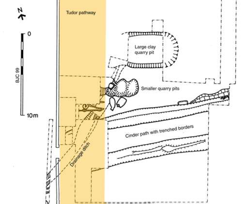
25. Mediaeval features located in the confines of the Walled
Garden. The large central pit was nearly two metres deep but Bradford Geo-physics
failed to locate it and many other profound features located just below the
topsoil.
The results are correspondingly disappointing (Figure. 24) and failed to detect several major archaeological features (Figure. 25) including a cinder metalled path with metre wide border trenches and a clay extraction pit of dimension L7.0-10.0x w4.2 x d1.7m later fully excavated in the Walled Garden project CT8. The areas covered were; Area 1, the Walled Garden; Area 2a, north of garden wall; Area2b, east end of Chapel; Area 3, north cellar, Area 4; south cellar. (note; these are titles given in retrospect as the survey signally failed to locate either cellar although the position of the north one was already known). The results were poorly presented in a report which also failed to include a location plan.
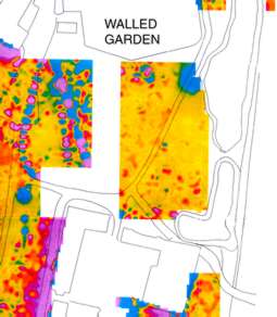
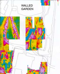

Figures 26 -28. Click image for larger version and explanation..
In June 1993 a far more comprehensive survey (Figures. 26-28) was undertaken by contractors Geo-Services International of Witney, Oxford using resistivity, gradiometry and magnetometry. The results from this were far more positive and diagnostic and were used in future project briefs to design and locate further excavations. The results were presented on scaled 1:500 digitised plots and printed in colour and grayscale. Unfortunately for reasons of funding the areas previously surveyed were not passed over again and this has left a hiatus in the record in the centre of the green. However, as this was largely excavated by the BVAS and also has the water main CT7 running through it, this gap is not really a hindrance to research.
![]()
Barry Hillman-Crouch. MSt PA, Dip FA, BSc, HND. Written 1999 Published on the web June 2005.